- Ohio History in 2000 Words
- Mound Builders
- Native Ohioans
- The Ohio Company
- Ohio's Wood Forts
- Indian Wars
- War of 1812
- Ohio's Canals
- Ohio's Road
- Scenic Railroads / Museums
- Underground Railroad
- Civil War in Ohio


Up until about 15 years after Ohio became a state going back to the time when Europeans first began trickling into the Ohio Country, there was a need to protect themselves from Native Americans who not only knew the Ohio Country better, many of them did not want the colonials coming here. Even those nationalities had built fortifications to protect themselves and their supplies from unfriendly attacks either by man or animals.
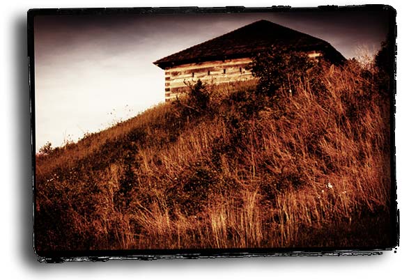
There are multiple classification of fortifications constructed in the Ohio Country dating back to the mid 1700s. The large wooden fortifications were built by either British, French or American military contingents. As the Ohio Country and later the state of Ohio became more populated and when threats seemed imminent, local citizens would for their own protection, construct what became known as blockhouses. These were typically a two level structure that was self contained, meaning there were no other walls and they weren't meant as a permanent structure, but in times of threat the local citizens could use the blockhouse as a gathering place, and if needed, a place to defend themselves from attack. These are not considered fortifications.
Fort Washington, along Ohio River, where the Great American Ball Park in Cincinnati is located.
A fortification is a structure built for defense by a military force. These can be further defined as either permanent or temporary. All of the wood fortifications built in Ohio were temporary field defensive positions. In all there were about 40 fortifications (not including the blockhouses) built in Ohio beginning in 1749. Of those 40 fortifications, only 5 were ever attacked.
Most fortifications were hastily built, designed to last for a short time. They were constructed as fall-back defensive positions and were about a days march distance between them. They were connected by roughly constructed roads that allowed supply wagons pulled by either horses or oxen to move through the woods and swamps. The fortifications could then provide protection during the nights.
Other fortifications were designed to withstand attacks by Native Americans and wild animals (bear, cougar, panthers). They were often designed by artillery officers that understood engineering and what was necessary to build something that could withstand an artillery barrage.
The three largest fortifications were Fort Washington in Cincinnati, Camp Greene Ville located in Darke County along the western border of Ohio, and Fort Meigs located just south of Toledo along the Maumee River. Both of these fortifications could easily accommodate more than 2,000 soldiers at one time. Fort Meigs was designed by military engineers and capable of withstanding an extended military-style siege. Camp Greene Ville was primarily used to provide over-winter protection for a large number of men in a defensible position.
Below is list of most of Ohio's Wood Fortifications.
Click on any of their names and read a summary of that fort.
The wood fortifications in Ohio were primarily built by government expeditions. There were also a number of other wooden fortifications that were built by early settlers. These were known as "Stations" and were often referred to by the name of the person organizing the settlement. Some stations could be nothing more than a log cabin and perhaps a barn where live-stock could be protected. These structures would face each other and be connected by a palisade of vertical logs with a gate.
Larger stations might have as many as ten families, cabins, and a livestock area. Each of the cabin's outer walls would make up part of the palisade. During times of uprising members would take turn standing watch.
Another form of protection was the central blockhouse. This was a singular, often 2-story structure designed to provide an elevated shooting platform should the structure come under attack. It also provided protected sleeping quarters for everyone in the nearby village.
If and when an alarm sounded everyone would rendezvous at the blockhouse and remain until the perceived danger had passed. By the end of the War of 1812, the need for fortifications of any kind had ended. Either the fortification was sold to be used as a store or business, sold for parts (especially nails) in which case the structure would be burned to the ground and the nails and other metal components would be salvaged, or it was just abandoned completely and left to decay.
©
Ohio City Productions, Inc.
All Rights Reserved.


Built by the French in 1745 - 1751, it was the only fortification built in the Ohio Country by non-English speaking people. Located at the western end of Sandusky Bay, on the northwest corner of the bay, it provided a beacon of sorts not only for the French, but later English explorers and expeditions where they could portage across the Marblehead Peninsula to Lake Erie. The Sandusky River could then be navigated north or south to another point where there was another portage to the Scioto River. It would become in years to come, a pivotal historical point.
The first fortification, which was nothing more than a hastily constructed cabin that identified the portage spot for the French when they came back exploring the Sandusky, Scioto and Ohio Rivers in the mid 1700s. In the mid 1760s the British may also have built a fortification here as well. During Pontiac's Rebellion in 1763, the Ottawa, under the leadership of Pontiac who was in an allegiance with the French, captured this fortification, and only one British soldier escaped a brutal death. The fort was sacked and burned.
Many years later in 1813, this site would be used by General William Henry Harrison as a rallying point for his men having recently repulsed a British invasion first on the Maumee River, and then on the Sandusky River at Fort Stephenson (where Fremont is located today). Harrison's men marched and rode along the old Sandusky-Scioto Trail while his supplies were transported by boat down the river to this point. From here their boats were dragged across the two mile path to the lake, and his men built a large corral to keep the horses secured with just a few guards. Once the horses were secured and the boats carted across the peninsula, he and his men boarded the Commodore Perry's small fleet of ships, having just brought about a major defeat of a British Naval force off South Bass Island.
Once Harrison's men were on board, the Perry's fleet departed from here to Fort Detroit where they once again engaged the British, and a large contingent of Native Americans being led by Tecumseh. In that battle, the British were defeated, and Tecumseh was killed, which for once brought a permanent peace to northwest Ohio and an end to Native American attacks here.
Built by the British in the Ohio Country during the French and Indian War halfway between the Sandusky River and Lake Erie. The fort was built on the southeastern side of Sandusky Bay in 1761. The year before the British took control of the French built Fort Detroit and the British decided to built a sort of half-way post on the southeastern shore of Sandusky Bay. This would give British expeditions coming from Fort Pitt on their way to Fort Detroit a place to stop. Once the fortification was completed, a small garrison of 15 men were left to man the fort.
Construction of this fortification however, was against a negotiated treaty between many Native American groups living in the Ohio Country that prohibited any British fortifications in the Ohio Country. It was this careless spark by the British that ignited a rebellion among the Native Americans.
With the French ceding control of the Fort Detroit and the Ohio Country in 1763, the Native Americans under the leadership of the Ottawa leader Pontiac, began a siege of Fort Detroit and an attack of all the other forts in the Northwest Territory. Seven of those fortifications were burned it to the ground including Fort Sandusky. Everyone except for Ensign Christopher Pauli were butchered. Pauli being the only officer, was taken hostage in hopes of trading him for a ransom. He however escaped his captors and fled back towards where the fort had stood and there met a relief column and went on to Fort Detroit. A year later a larger British force arrived here and after a short attempt to rebuild the fortification, those plans were abandoned.
Fort Sandusky included a single block house surrounded by a picket wall and was located just west of present day Sandusky in a small community named Venice where an historical marker has been placed identifying the likely location.
The fortification was built in 1774 at the confluence of the Hockhocking (Hocking River today) and Ohio Rivers. It was built before the American Revolution by the British to both protect colonists from Native American attacks and to keep colonists from crossing into the Ohio Country.
The fortification was built under orders from John Murray (Lord Dunmore, the British governor of Virginia). As Lord Dunmore was leading a military force down the Ohio River from Fort Pitt, he sent ahead about 1/3 of his force led by William Crawford, an experienced Indian fighter and backwoodsman. It was Crawford that built Fort Gower on the east bank of the Hocking River.
Fort Gower was a crude fortification quickly built with Crawford's 500 men. It had one blockhouse. When Lord Dunmore arrived, he named the fortification Fort Gower after Lord Gower a member of the British Parliament back in England. The fortification was too small to protect the 1500 men gathered there, and was instead was used as a large stock yard to protect the livestock. Lord Dunmore left 100 men to protect the fortification and went up the Hockhocking River to about where the town of Logan is located today. From here his force traveled about 30 miles west to the Scioto River and setup a camp here he named Camp Charlotte.
At Camp Charlotte, Lord Dunmore met with most of the warring Native Americans and signed a treaty with them. The one exception was Chief Logan who refused to sign the document.
Fort Laurens in northeast Ohio along the Tuscarawas River and north of Dover, was the first and only fort of the Revolutionary War. It was built out of gross incompetence of the American general Lachlan McIntosh who ordered the fort built. In most history books, General Lachlan McIntosh is credited with building the fort in 1778 as a defense against British and native peoples, which is true. But few tell the rest of the story.
General McIntosh had left Fort Pitt after being granted permission by the Delaware to cross their lands on their way to attack a British outpost known as Fort Detroit in 1778. However, this force of 1200 frontier militia was ill-trained for a cross-country march. The force also didn't leave Fort Pitt until late October. It took the force much longer to navigate the land and move their supplies. When McIntosh realized his goals of attacking Fort Detroit before winter, he decided to build a fort along the Tuscarawas River.
Using the 1200 men under his command, they quickly constructed the picket style fortification. It covered about an acre of land on the west side of the river with an excavated ditch surrounding 3 sides. The fort was originally built by some 1200 military, and then maintained by 174 men. The fort was abandoned in 1779. The name Laurens after Henry Laurens, president of the new Continental Congress. The small garrison stationed there suffered from hunger and Indian attacks throughout the time they spent there.
Although Fort Laurens was well designed and constructed, it provided no strategic advantage for American forces during the American Revolutionary War. It was too far from Fort Pitt to be adequately supplied. It was too far from Fort Detroit to become a staging location in attacking that British outpost. And, it was too far from the Moravian missionaries located south of the site.
Read more about Fort Laurens, its construction, and the memorial that exists there today ![]()
Fort Harmar was located at the mouth of the Muskingum River where it enters into the Ohio River on the west side of the Muskingum River. When Fort Harmar was originally ordered built by an act of congress its mission was remove illegal American settlers from the north side of the Ohio River.
The fort consisted of horizontal log walls with several bastions to keep those walls in position. There were also four palisades that offered that provided additional support for the horizontal walls as well as improved firing lines in the event of an attack. Overall the fort had a pentagon shape. Inside the walled fort were several 2-story buildings for officers and family with barracks for the troops. There was also an arsenal and a store house with a watch tower that gave an elevated view of the rivers and land surround the fort.
The first military garrison stationed here quickly realized richness of the soil and planted a large vegetable garden and fruit trees.
Fort Harmar became the United States' main military base and its five-sided pentagon shape was perhaps a sign of what would later become the military center of the world: the Pentagon.
In 1788 the Northwest Territorial Governor, Arthur St. Clair arrived at Fort Harmar to take up his duties regulating the territory. In 1790 most of the garrison at Fort Harmar was transferred to the newer, bigger Fort Washington down river where Cincinnati would be established.
Built in 1787 by the 1st American Regiment to protect government surveyors from the area's hostile Indians as they surveyed the first 7 ranges of the Northwest Territory. Although Fort Steuben was only functional for a short period of time, its presence allowed the surveying crews to carry on their surveying responsibilities. This was the first time that a serious survey of the Ohio Country would be attempted. It was also the first time that the guidelines set down by Congress on how the territory would be surveyed.
In the Land Ordinance of 1785, Congress set out that the new territory would be divided into square 6-mile townships. Each township would then be divided into 36 sections, with each section being 1 square mile.
As the surveyors began to spread out to do their work, they came under increasing threats from the Native Americans. As it became clear to Josiah Harmar that more military were necessary to insure the safety of the survey crews, he decided to build a temporary fortification along the western side of the Ohio River.
Captain John F. Hamtramck and soldiers from the 1st American Regiment, began building the fort in the late fall of 1786. That fortification would have four blockhouses with a palisade wall. Its gate faced the river. However, construction had fallen behind and Captain Hamtramck wanted the fortification completed before winter struck. To help inspire his men to get moving, he introduced a contest between the companies. Each company would be responsible for completing one of the three remaining blockhouses. The winning company would be rewarded with 6 gallons of whiskey. The blockhouses were completed in record time and just days after the men moved into their new quarters, an early winter storm struck dropping 2' of snow and freezing the Ohio River.
It named for Baron Von Steuben, the man responsible for organizing and training the Continental Army at Valley Forge and instituted a program to improve the camp's sanitary conditions, which cut down on the number deaths from illness. From his efforts at Valley Forge, Von Steuben was appointed Inspector General of the Continental Army.
On May 23, 1787 the fort was abandoned. In total it was only occupied about 7 months. The town that grew up around the former location of Fort Steuben became Steubenville. In 1986 the land where the original fort stood was purchased, and a reproduction of Fort Steuben was built.
It wasn't until towards the end of the summer of 1789, that Josiah Harmar ordered Fort Washington to be built. This new fortification would be a large, well built fort and would be used until 1804. With Harmar's previous experience, his men constructed the fort unlike any other frontier fortification up to that time. Its stone foundation and reinforced walls provided protection from light artillery fire if that were to happen. Some of the wood used in the flooring of the construction, came from Kentucky boats discarded by pioneers upon completing their journey down the Ohio River. Harmar joined his men at the fort in December of 1789 and officially moved his headquarters here. It wasn't until Harmar arrived and seeing the actual fortification, that he sent word to the Secretary of War that he had chosen the name of Fort Washington "on account of its superior excellence" to honor the new president.
From this fortification, 3 major military campaigns would be launched. Two of these campaigns would end in defeat. The third would result in the signing of the Treaty of Greene Ville, a major milestone in the settlement of the Ohio Country and the eventual formation of the state.
It became apparent during the previous military expedition into the Ohio Country by Brigadier General Josiah Harmar, that moving a large military into the wilderness without being supplied would be disastrous. When Northwest Governor Arthur St. Clair prepared for his campaign into the Ohio Country he began constructing a series of supply depots that would help protect relief missions the further the main body moved north. The first of those supply depots was Fort Hamilton, which was constructed in September 1791. The fort was the first of many built north from Fort Washington. Fort Hamilton, named for Treasury Secretary Alexander Hamilton and served as a supply depot for American expeditions against Native Americans living along the Great Miami River, the Auglaize River, and the Maumee River during the early 1790s.
Fort Hamilton was designed by Major William Ferguson, the man who supervised actual construction of Fort Washington, which was designed by Lieutenant John Pratt. Fort Hamilton located about 22 miles directly north of Cincinnati had four blockhouses with two of those included artillery platforms. Inside the palisade were barracks for 100 men, several storage sheds. St. Clair spent a lot of time on the fortification's details and in the construction of the site. It took just about 2 weeks to complete.
Six months later the fort was expanded and made more comfortable for its occupants. The site of this fortification became the city of Hamilton. There is a small park with an historic log cabin placed in a point that would have been inside the forts walls. It however, was added to the site in the 1960s. Most visible is the the tall Soldiers, Sailors and Pioneers monument.
Located in present-day Darke County in far western Ohio, Fort Jefferson was built under the direction of Governor Arthur St. Clair in October 1791 as an advance post for his campaign from Fort Washington against local Native Americans. A square of approximately 100 feet on each side, the fort was built of wood and intended primarily as a supply depot; accordingly, it was originally named "Fort Deposit." Before St. Clair's army departed the fort, a court-martial was conducted for an unknown crime; the three soldiers who were convicted and hanged became the first whites to be executed in present-day Darke County.
Fort Jefferson became the fall back point for the survivors of St. Clair's army after being attacked on the morning of Nov. 4, 1791. The following year in June, as some soldiers were gathering hay being grown in the fields around the fort, Native Americans attacked the men and killed 15 of the soldiers. Over the next two years, there were sporadic attacks against the fort.
Governor Arthur St. Clair ordered a chain of forts built northward from Cincinnati in order to project United States power into Native American territory. Following St. Clair's Defeat in November 1791, the United States Army retreated to Fort Jefferson, Fort Hamilton, and finally Fort Washington. Major General St. Clair departed for Philadelphia in January 1792, and Lieutenant Colonel James Wilkinson assumed command of the United States forces at Fort Washington. Wilkinson noted that it took two days to travel from Fort Hamilton to Fort Jefferson, which contributed to the suffering of the wounded who could not leave Fort Jefferson following St. Clair's Defeat. Wilkinson ordered the construction of Fort Saint Clair between the other two forts in order to secure communications and supply convoys between the chain of United States outposts
Camp Greene Ville had fortification positions, but it was more like a military base, that is it wasn't meant primarily as a defensive structure. General Wayne named this site after a good friend of his, Nathaniel Greene. Unlike most fortifications of this era, Greene Ville was laid out much like a small city. In fact, if a city map of today was placed on top of the original Greeneville plat, many of the streets would line up with the original fortification. A double row of cabins, with each cabin housing 10 men, ran around the inside of the exterior walls. Each corner of the fort had a bulwark for defensive purposes of the walls. Blockhouses were built into the central wall of each side. Eight redoubts, each with a blockhouse, surrounded the main stockaded wall.
Greene Ville was constructed in 1793 as the winter quarters for his expeditionary force. This location was about 6 miles beyond Fort Jefferson and as he was advancing word came that a supply convoy had been attacked following the main force. Deciding that since winter was approaching and this particular site where St. Clair had camped earlier, it offered everything he thought important. Water, elevated position, clear field of fire and plenty of nearby timber. The outer perimeter of the camp was complete on November 21, 1793.
Greene Ville as abandoned in 1796, but was reoccupied in 1805 by Tecumseh and his brother the Prophet. Two years later, future governor Thomas Worthington came to the camp to talk with Tecumseh and went back to Chillicothe so Tecumseh could address the Ohio Legislature.
William Henry Harrison met with Native American representatives at Greene Ville in 1814 to discuss peace terms.
Read more about Camp Greene Ville and the Treaty of Greene Ville ![]()
In December 1793, General Anthony Wayne sent an artillery unit and 8 infantry companies to the site where Major General St. Clair was defeated. Here they were to build a fort on a former battlefield. That battle known by various names such St. Clair's Defeat, Little Turtle's Victory, but it is best described as the Battle of the Wabash.
There were a variety of reasons why the Battle of the Wabash became the largest defeat of American soldiers in the history of the United States Army fighting against Native American forces led by Miami leader Little Turtle. This battle happened on November 4, 1791 and included approximately 1,400 regular military, militia, inductees and camp followers which included both women and children. At the time of the attack Native Americans numbered by most estimates to be 1,500, but while the forces may have been similar in size, Little Turtle was a superior field general. St. Clair also had a battery of artillery, but in this particular location and the position of the artillery pieces, they provided no superiority. Although artillery pieces were repeatedly fired, they did no damage whatsoever because of the elevations. The smoke resulting from the cannon fire, provided excellent cover for the Native Americans.
During that fight 900 Americans were killed with 350 wounded. Some estimates suggest that as few as 30 warriors were killed. Two years later, General Anthony Wayne arrived here with a newly formed American force of well-trained, and well outfitted soldiers. Understanding the importance of this site, General Wayne ordered a fortification built. General Wayne intended to use this fort as a staging area for his assault against Ohio natives when the weather warmed in the spring of 1794. He named the stockade Fort Recovery. During that winter as General Wayne's men completed the fortification, he began receiving additional men and supplies from Fort Washington.
When completed, General Wayne named the new fortification Fort Recovery. That summer, on June 30, 1794, an assault on Fort Recovery began. Leading a coalition of 2,000 Native Americans, Little Turtle once again did battle with American soldiers. Bolstered by an even larger force and with the backing of British munitions and supplies, Little Turtle felt confident of a repeat win. But this time Little Turtle was out matched by a better trained, better led American force that also had the advantage of a wood fortification. On July 1, 1794, Little Turtle withdrew his warriors retreated north.
General Wayne assembled his forces and followed Little Turtle and his large coalition. On August 20, 1794 he engaged them along a tree-strewn plain that became known as the Battle of Fallen Timbers.
Fort Adams was a small star-shaped fort with two blockhouses at opposite corners and was constructed as part of General Wayne's campaign north from Fort Washington to the Maumee River in 1794. It was another supply depot fortification. It's exact location has not been officially recognized by the state. However, in 1998 archeologists from Heidelberg College and local volunteers conducted an extensive search of a site they believed may have been Fort Adams along the St. Marys River in Mercer County.
This fortification was the smallest of the wood fortifications constructed during General Wayne's campaign.
Fort Defiance first saw service during the Indian Wars of the 1790s. After the Battle of Fallen Timbers, Wayne used the fort as an operational center used to seek out and destroy Native American villages within a 50 mile radius of the fort. After the signing of the Treaty of Green Ville, Native Americans allowed for the fort to be converted into a trading post. With the outbreak of the War of 1812, Harrison repaired the fort so it could again become an active fortification while other forts were constructed nearby.
Camp Deposit was constructed by General Wayne just before he engaged the enemy in what would become known as the Battle of Fallen Timbers. Wayne realized the enemy was not far in front of him as he progressed along the west side of the Maumee River. Deciding not to carry any more supplies than absolutely necessary, he had the men build a temporary fortification here where they could "deposit" their supplies. The fortification was protected by a small contingent of men under the leadership of Captain Zebulon Pike.
Taking the time to build this relatively minor fortification gave General Wayne a major advantage in his campaign against the Native Americans waiting less than 5 miles north of him along the Maumee River. First, the fortification meant that his men could go into battle unincumbered with camp supplies and equipment. All of this could be left in place. This fortified position could also provide a point to retreat to if things went badly in the coming battle. But, the biggest advantage was that the Native Americans were expecting that Wayne's force would be engaged the following day. Native Americans followed a practice of fasting the just before a battle. The reason was if a man was wounded in the stomach, he would be more likely to survive if his stomach was empty.
General Wayne's decision to build Camp Deposit, delayed the engagement for more than a day which meant the warriors had not eaten for more than 24 hours, and had decidedly less energy than they would have had otherwise.
Once battle of Fallen Timbers as it became known, was over, Wayne's men destroyed nearby Native American villages and farmlands. They then returned to Camp Deposit gathered their equipment and materials for the return trip to Greene Ville. There is no marker but it is believed this temporary fortification was on the north side of the Maumee River near just south of Waterville.
Fort Miamis was an earthwork fortification located on the west side of the Maumee River and just south of Toledo. Designed and built by Royal Engineers, Fort Miamis consisted of 4 diamond shape earthen walls called bastions. The British dug a 24' deep trench around the fort and lined it with rows of stakes to slow an enemy's assault of the fort. The British also placed 14 cannon in the fort to thwart any attackers. The fort was designed to defend the land and water routes to Detroit against American forces under General Anthony Wayne.
After the Battle of Fallen Timbers just south of this location, many of the Native Americans retreated to this position for protection from General Wayne. They however, were refused admission into the palisade. The British did not want to engage the Americans in an armed conflict which they feared might happen if allowed entry of the Native Americans. General Wayne, satisfied with the results of the battle, instead sent some of his force on a search and destroy mission of all the local Indian villages.
On January 1, 1796 according to the terms of Jay's Treaty, Fort Miamis was surrendered to the Americans who occupied it until 1799 at which time the site was abandoned. During the War of 1812, the British once against occupied the site until it was abandoned after the last siege of Fort Meigs in 1813.
Fort Piqua, located on the west bank of the Miami River north of Piqua, was a supply fortification built by General Wayne in 1794. It was comprised of several buildings and a single blockhouse. One of the wagon masters, a 17 year old Irish immigrant named John Johnston had a layover at Fort Piqua while moving supplies north for General Wayne. Many years later Mr. Johnston was appointed by President Thomas Jefferson was appoint as an Indian Agent and stationed at Fort Wayne. In 1811, a new agency was set up in Piqua. Johnston being familiar with the area established a farm where the old Fort Piqua once stood. Today, Johnston's Farm is a preserved historic site.
During the Indian Wars of 1793-1794 General Anthony Wayne ordered construction of Fort Loramie. It was located at the portage between St. Mary's River and modern-day Loramie's Creek.
Wayne initially intended Fort Loramie to be an actual stockade, but after defeating a large group of Native Americans at the Battle of Fallen Timbers in August 1794, he decided a blockhouse and several storage buildings were more important.
When the War of 1812 erupted, the abandoned fort was once again occupied and defended as a supply depot. After the war the fort became a tavern.
Built by General Wayne during his campaign to the Maumee River in 1794. The fort was a supply depot on the St. Mary's River.
Fort McArthur that constructed by Col. Duncan McArthur in 1812. This fort was along the trail that General Hull's men created as they marched toward Fort Detroit and promptly surrendered at the onset of the War of 1812. Later the village of Kenton was built just down the road from the fort.
Fort Findlay was a stockaded supply base about 50-yards square, with four blockhouses. It was ordered built by General Hull on his way to Fort Detroit where he surrendered his forces to the British.
Colonel James Findlay carried out those orders to build the fort and a road from Ft. McArthur on the Scioto River to Blanchard's Fork. After he carried out those orders the fort was named in his honor. Immediately after the war the fort was occupied by some Wyandot Indian families that were common to the area. The village of Findlay was laid out in 1821 along the Blanchard River not far from where the fort stood.
Built in Cleveland by orders of Secretary of War John Armstrong who wanted General Harrison to make this position his campaign headquarters after the surrender of General Hull. Harrison felt his position should be on the western front, which he did. Fort Huntington was named for the previous governor of Ohio, Samuel Huntington. On June 19, 1813 the lookouts at the fort spotted sails on Lake Erie and they opened fire. Fortunately, no damage was done as the ship fired upon was American.
Built under orders from General Harrison, it was built by Colonel Joshua Barbee not far from the old Fort St. Marys which had fallen into disrepair. It was decided building a new fortification would be easier than trying to repair the old one. Fort Barbee was located on the St. Marys River and was a supply depot. When Fort St. Marys was built, there was a small trading outpost here along with a few cabins. It was known regionally as Girtystown. This name remained until the name St. Marys became the official name in 1823.
Originally built in the fall of 1812 by Kentucky troops under the command of Lt. Col. Robert Pogue who named the fortification for his 11-year old daughter. The fort was enlarged to almost double the original size during the spring of 1813 by Ohio militia soldiers under the command of Capt. Daniel Hosbrook. Today there is a granite monument in Fort Amanda Park named that was erected in 1915 at the site of the original fort. The monument as well as the cemetery can be viewed during daylight hours.
Building by Colonel William Jennings began on September 21, 1812 and was completed in October of that same year by Jennings regiment of Kentucky riflemen. The fort was located on the bank of the Auglaize River. They also constructed a road from Fort Barbee to Fort Jennings, which was about halfway between Fort Barbee and Fort Defiance. Today the town of Fort Jennings is located here.
Located near Fort Defiance, which was built in 1794 by General Wayne, Fort Winchester was constructed just south of the old fort in 1812 along the west bank of the Auglaize River. It was named for the American General James Winchester, who had initially been named commander of the western forces. However, it became quickly apparent that General Winchester was inadequate for the assignment and was deeply disliked by his men. It was decided that General Harrison would be a better commander of the western frontier. Winchester then took control of the extreme western American forces positioned at Fort Wayne. Winchester's forces became the left wing of Harrison's 3 divisions.
Under Harrison's orders, Winchester moved his forces down the Maumee River to Fort Defiance. When they arrived here from Fort Wayne they found the old fort was too small and in such disrepair that a new fortification should be built. For a time this was the most northern fortification for the American army during the War of 1812 until Fort Meigs was constructed a few months later. As such, it was sporadically supplied and as a result, the men manning the fort, made an inscription above the front entrance naming the fortification Fort Starvation.
The fortification consisted of 4 block houses connected by a continuous wall of thick log pickets about 12' tall and tightly fitted together. The blockhouses were roofed over with logs and then covered with earth. An underground passage was also built from inside the fort down to the Auglaize River. If the fortification came under attack those inside could retrieve water without being fired upon.
After constructing Fort Winchester, Brigadier General James Winchester ordered his troops across the Maumee River to the north side. Here they built temporary earthen walls for concealment. While close to the main fort, it was a poor location that was poorly drained. This site became Camp #2. In time the Winchester ordered his army about six miles further down river which became Camp #3.
It has been reported that as late as 1822, 2 of the block houses and 2 store houses located originally inside the picket walls, were still standing and inhabited.
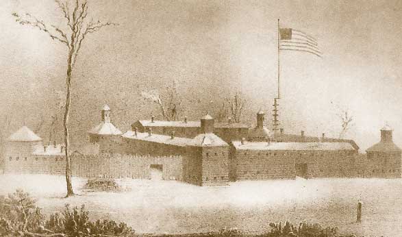
Fort Meigs located just south of Toledo, along the banks of the Maumee River, was the largest fort constructed in Ohio during the War of 1812. Under extremely adverse conditions, General Harrison urged his men to construct the fort in record time. It would become a focal point in the British invasion of northwest Ohio. The largest battle fought in Ohio during that war was fought here against superior numbers of British forces and an alliance of Native Americans led by Tecumseh.
Construction of the fort began in February 1813 during an especially cold winter and was completed by the end of April and named for the governor of Ohio, Return J. Meigs. When completed the strategically placed fort designed by military engineers and capable of withstanding an extended artillery siege if necessary. Most forts constructed at this time were only designed to repel Native American attacks and keep out wild animals. Fort Meigs would be able to withstand almost any attack. Besides the 15' high stockade-style walls, there were interior earthworks designed to absorb incoming artillery shells without harming occupants.
The fortification was one of the few built in Ohio that had artillery pieces capable of firing upon attackers. The problem was a shortage of cannonballs. When the siege began on May 1, the British fired 500 cannonballs into the fort in one day. The Americans had only a total of 300 cannonballs total. But, since the British were using non-exploding balls, the Americans began retrieving the spent balls and re-using them against the British.
This stockaded position located just east of where the Wyandot County Court House in Upper Sandusky now stands. It was used as a supply depot and was located on a bluff along the western side of the Sandusky River.
Colonel James Ball was tasked with building roads for General Harrison. Ball was a calvary officer and had constructed a temporary holding pen for his horses and established a camp here for his men. The site was chosen thanks to some friendly Wyandot who suggested this particular site. General Harrison suggested that the colonel build a more fortified position that could be used as a defensive position.
The fortification was about 40 miles east of Fort Meigs on the Maumee River and about 10 miles south of Fort Stephenson. Fort Ball was built before Fort Seneca was constructed that would become General Harrison's headquarters after he left Fort Meigs.
Fort Ball was built on the west bank of the Sandusky River in less than a week, in what is now the city of Tiffin. It was a fairly small stockade, enclosing perhaps one-third of an acre. The stockade was constructed around a natural spring. On the eastern side facing the Sandusky River, Colonel Ball constructed 3 block houses facing the river. Once Fort Seneca was completed, some of Harrison's men were sent to Fort Ball to relieve the calvary positioned there.
Once the fort was completed, it was almost never used.
Fort Seneca was built as a stockade by a detachment of Gen. Harrison's army. Although it was used as a supply depot, it was also used by General Harrison as his headquarters. From here he could be in contact with Fort Meigs, Fort Stephenson and the supplies lines coming up from Columbus. The fortification stood on the west side of Sandusky River about 10 miles south of Fort Stevenson.
Fort Stephenson was at the head of navigation on the Sandusky River, on the site of present Fremont. This was a natural site for a fortification. The Sandusky River up to this point could be navigated with ships from Lake Erie. At this point there was a series of rapids that made further ship travel impossible. In early 1812 the site was fortified with a blockhouse and was unofficially called Fort Sandusky. But when General Hull surrendered in late summer of 1812, work was abandoned for fear that the British would soon be arriving. In the fall of 1812, a group of militia from around the Huron River area arrived here in search of food that may have been left behind. Finding plenty of food, they sent a contingent back to Camp Avery, with the rest of the men working on the fort. In December 1812, another military force arrived and added to the fortification. The following month militia under the command of Colonel Mills Stephenson completed the fortification and named it after their colonel. When General Harrison began building Fort Meigs, the men working on Fort Stephenson left and helped in that construction.
The fort was well constructed and enclosed an acre of ground. It was the site of a military engagement that received the admiration of the entire country. During the War of 1812, the British and Native Americans attacked Fort Meigs along the Maumee River. After laying siege to the fort for several weeks, this plan was abandoned and the forces withdrew back to Lake Erie. From here they circled around and came down the Sandusky River to mount a rear attack against Harrison. When they arrived at Fort Stephenson, the British disembarked and set up their artillery pieces in preparation for an attack on the fort.
When asked to surrender, American Lieutenant Shipp replied: "My commandant and the garrison are determined to defend the post to the last extremity, and, bury themselves in its ruins, rather than surrender it to any force whatever." Thus began the battle between a 21 year old American major named George Croghan and British General Henry Proctor. On the second day of August, 1813 Croghan, against a vastly superior force, won the victory which proved to be one of the major turning points in the war of 1812. Once Proctor was defeated at the fort, he withdrew back to Fort Detroit with General Harrison following close behind. It was also shortly after this that Commodore Perry decisively defeated the British fleet in Lake Erie.
Read more about Fort Stephenson and Major George Croghan, who was later buried on this site![]()