- Ohio History in 2000 Words
- Mound Builders
- Native Ohioans
- The Ohio Company
- Ohio's Wood Forts
- Indian Wars
- War of 1812
- Ohio's Canals
- Ohio's Road
- Scenic Railroads / Museums
- Underground Railroad
- Civil War in Ohio

 With the passage of the Northwest Ordinance of 1787 rules were set down governing how the United States of America would continue forward and established the precedent that the country could expand westward from the original 13 states. It also established that states north of the Ohio River would be admitted to the Union as slave-free states. Also included in this ordinance were provisions to survey the Northwest Territory.
Surveyors were responsible for converting uncharted wilderness into tracts of land that could be marketed and sold. This was done by creating townships that depending on who was doing the survey were either 36 square miles or 25 square miles. Once the township was created, it could then be subdivided by individuals into any size and configuration they wanted.
It was up to the surveyors to give not only accurate descriptions of the land, but sometimes glowing descriptions of the land. In most cases, those purchasing large tracts of land had never seen the land they were buying. In the case of speculators, they may never see the land. It was therefore left to the surveyor's description to see the property for top dollar.
When the land opened up to survey by Congress in 1790, there was a rush of surveyors into the land northwest of the Ohio River. Premium prices would be paid by speculators for the best land. To insure these speculators got title to the best lands, they offered their surveyors generous contracts that more often than not awarded one fourth or even a third of the surveyed land. In some instances even as much as one half for really good land was awarded the surveyor. In some cases the surveyors were paid in cash.
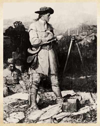 Fees paid to these early Ohio surveyors may seem extravagant today, in the late 1700s, life on the frontier required a special person with a special set of skills. with grit, determination and fearless personality. Surveying often took place during the winter months when the threat of attack by an Indian hunting parting was greatly reduced as they were more likely to be in their winter quarters.
Each survey team entering into the Ohio territory began with the team leader. Experienced leaders were often given the title of colonel. They were responsible for the entire excursion including selecting all the men that would take part. The colonel would be an experienced surveyor, one that was familiar with the frontier and that understood the demands. Under him would usually be three assistant surveyors. Each surveyor would be accompanied by six men, each with a specific job function, making a total of 7 men. All totalled, each excursion would consist of twenty-eight men.
In the field where Indians could be encountered at any time, great care was taken to insure the safety of the team. In the lead position walking about two or three hundred yards in front of the surveyor was the hunter. His job was to scout for game and be on the lookout for any signs of danger in the form of Indians. Next was the surveyor, two chainmen, marker and a pack-horse man that carried the baggage. This group always kept close to each other and were always armed and prepared to fend of an attack. Bringing up the end about two-hundred yards behind came the last member of the team, a man they called the spy. His responsibility was to keep on the back trail and make sure the surveyor party up ahead was not being followed. Each man in the team carried his own rifle, blanket and any other personal items required for survival in the wilderness. The packhorse carried cooking utensils and provisions that couldn't be obtained from the wilderness.
Each evening the teams would come together. Each would build a single fire and prepare their food. After the meal, as long as there had not been any Indian sighting the men would tell stories and sing songs to pass away the evening. When it came time to settle down for the night, a signal was quietly given and the men would pickup their rifles, blanks and personal gear and without a word being spoken, leave their fires and walk as quietly as possible about three-hundred yards away from the fire. Here they brushed away the snow and made their bed for the night. Half of the blankets were laid upon the ground, the men then laid down one closely beside the other with the other half of blankets covering them with their rifles at their sides. Here they remained until daylight the following day. 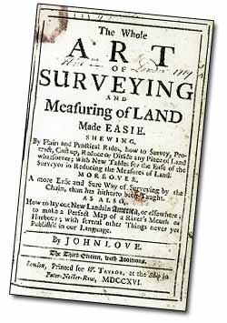 Once daylight arrived, two men would be sent out to circle the smoldering camp fires to make sure that during the night no Indians had set up an ambush when they returned to their fires.
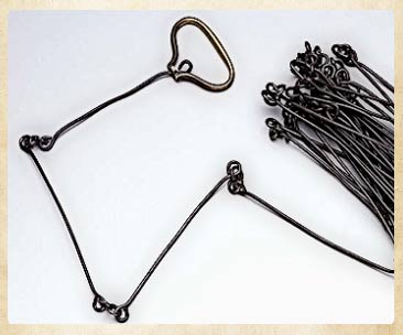
Surveyor's tools were minimal and relatively inexpensive. A compass or circumferentor, a gunter's chain, and a set of plotting instruments were that was required. Also required was a good supply of gunpowder, a well maintained rifle, and a kit that contained a blanket and other personal items one might need over a long period of time in the wilderness.
The Connecticut Western Reserve was unique in the Ohio Territory. This land was claimed by the state of Connecticut even after they had given up claim to land that extended through New York and Pennsylvania. The rest of Ohio was under federal jurisdiction and protection. But the Western Reserve lands were under the jurisdiction and protection of the state of Connecticut.
Moses Cleaveland was the principle surveyor of this land that began along the western boundary of Pennsylvania, south to the 41st north latitude, north to the shores of Lake Erie. Unlike other surveyors, he chose a specific grid system what was broken into five mile by 5 mile rectangles regardless of the terrain. Other surveyors might just use a river or other geologic feature as dividing line. Moses' method while simple on paper, actually created many problems for his surveying teams in that they had to physically layout the grids regardless of the terrain.
Using the grid method allowed the land to be divided up equally among the stockholders of the Connecticut Land Company. The straight line grid was used everywhere in the Western Reserve except for where the grid lines intersected the shores of Lake Erie or the Cuyahoga River. Here the natural features were used. On average a good surveying party would survey about 12 miles in one day.
Unlike other surveying parties, surveyors of the Western Reserve had to proceed through the woods running a straight line from one fixed endpoint to the next. The axe man would clear a path through the trees and the underbrush while the flagman provided as a sighting target for the surveyor. Once the straight line was cleared, two chainmen would measure the distance and set a mark identifying the distance. The surveyor would then bring up the rear sighting using an accurate compass to make sure the crew stayed on course. Pack horses followed carrying necessary supplies that would be needed.
Once the township survey was completed, the chief surveyor would make specific notes as to the features of the land, how the land might be used, the general character of the land (wooded, swampy, hilly, flat, etc.). This information would then later be used in advertisements created by the land company to sell lots in the township.
The act of surveying the land forever changed the nature of the land. Before the wilderness was one continuous stretch from one geographic point to another. After the survey, the land had become a grid of rectangles that could be quantified and identified. The land had become a quantified piece of property that could be titled and sold like so many cords of wood.
©
Ohio City Productions, Inc.
All Rights Reserved.

