- Ohio History in 2000 Words
- Mound Builders
- Native Ohioans
- The Ohio Company
- Ohio's Wood Forts
- Indian Wars
- War of 1812
- Ohio's Canals
- Ohio's Road
- Scenic Railroads / Museums
- Underground Railroad
- Civil War in Ohio

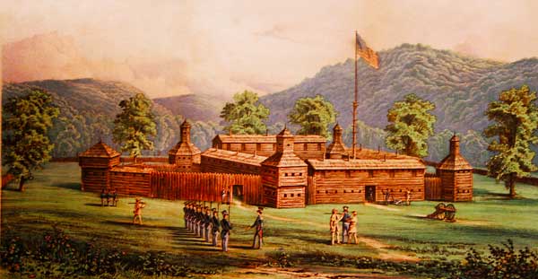
In the above painting, it is believed this view would be looking toward the northeast. The larger hill in the background would probably be Mt. Auburn.
After the Revolutionary War, a wave of settlers were coming down the Ohio River and into the Northwest Territory looking for opportunity, or a new start. When the Treaty of Fort Harmar was signed, there was a change in the government's position. That treaty, signed by a few Native Americans, gave the government the green light to allow settlers to start making legal claims north of the Ohio River.
Land speculators began buying up large 640 acre chunks of land, and breaking those into smaller tracts that more people could reasonably afford. Surveyors began risking their lives in the Ohio Country surveying these 640 chunks of land which could then be legally divided with a deed.
At this time Josiah Harmar who was in command of the First American Regiment garrisoned at Fort Harmar, decided to move his headquarters further down the Ohio River to a point where for the present, a stronger military presence was needed.
John Symmes had already begun buying and selling land in the Ohio Country. It appeared to John Symmes this venture would be a profitable venture if, and it was a big if, the constant threat of Indian attack could be removed. The more land that was sold, the more the killings and butchery increased.
Native Americans in the land along the Ohio Country had previously signed a treaty at Fort Harmar that gave the Americans the right to sell land north of the Ohio. But not all the Native Americans had signed the Harmar Treaty. In fact they refused to sign that treaty.
The treaty signed in early 1789 was with some Native Americans that may or may not have understood the terms of that agreement. There were some, and in particular the Shawnee, who understood exactly what the treaty meant and they refused to negotiate much less sign the documents the government were presenting and for good reason.
Native Americans had long protested the presence of American settlers moving onto the land north of the Ohio River. Many Native Americans in the Ohio Territory had sided with the British during the American Revolution hoping this alliance would fend off the advancing Americans. During that war, a military expedition led by George Rogers Clark moved up from what is now Cincinnati and completely destroyed a Shawnee village near present day Piqua. These attacks left deep scars that would haunt the Shawnee until after the end of the War of 1812, a war which took their leader Tecumseh.
It was under these circumstances that the future Fort Washington was going to be constructed and it would be no ordinary fortification. When completed the magnificent fortification, perhaps the best fortification in all of the western frontier, could only be named after the ranking military officer in the country, President George Washington. It was Harmar's decision and Northwest Territorial Governor Arthur St. Clair upon touring the new fortification agreed. He also suggested that the little shanty town that had been thrown up around the new fort and which had become known as Losantiville, be renamed after a new organization for veteran officers of the Revolutionary War called the order of Cincinnatus.
The location of the fort was ideally sited by Harmar's construction crew. At this particular point, the Ohio River was much shallower and made an ideal landing. The fortification's foundation would be made of stone and it was laid up on the second flood plain, a site that would be high enough to avoid being flooded.
The main body of the fort was 200 feet square. The main gain faced toward the river. On each corner 2-story blockhouses provided adequate vantage points to fend off any attack. Inside the walled fortification, a number of 2-story frame houses were constructed, built mostly with discarded timber from the scores of flatboats that had landed here and gone no further. A well was dug to provide adequate water as needed. The main fortification was added to on the north and west sides.
Fears of conflicts between the settlers and the Native Americans were heightened. Even with the treaty, which many of the Native Americans in western Ohio did not recognize, the conflicts increased. A wealthy landowner, Judge John Symmes, had purchased a large track (400,000 acres) of land along the Ohio River between the Miami and Greater Miami Rivers, to sell off in lots to the new rush of settlers.
Concerned over the Indian attacks that would eventually hurt his land sales so he petitioned the US Congress to do something about the problem and provide protection. That job fell to the senior officer of the United States Army, Josiah Harmar.

It wasn't until the end of the summer of 1789 that Harmar ordered construction to begin on Fort Washington. With Harmar's previous experience, his men constructed the fort unlike any other frontier fortification. Its stone foundation and reinforced walls provided protection from light artillery. Some of the wood used in the flooring of the construction, came from Kentucky boats discarded by pioneers upon completing of their journey down the Ohio River. Harmar joined his men at the fort in December of that year and officially moved his headquarters to the new location. It wasn't until Harmar arrived and seeing the actually fortification, that he sent word to the Secretary of War that he had chosen the name of Fort Washington "on account of its superior excellence" to honor the new president.
The fort was placed above the flood plane about 1000 yards from the river. It was laid out in a rectangular shape facing the river. A two story command post and a well were centered in the fort with additional two story blockhouses on each corner. Triangular extensions were added later to the north and west sides. This sturdy and impressive fortification would see both General Harmar in1790 and General St. Clair in 1791 lead their men into punishing defeats against Chief Little Turtle. In 1791, an 18 year old ensign, William Harrison, arrived at the fort to begin his military career on the frontier. He who would later become president of the United.
It must have been extremely reassuring for new settlers coming down the Ohio River to see Fort Washington high up on the bluffs of the river providing them a sense of relief and protection that they may not have felt since leaving the safety of the east.
After Harmar's Expedition and its resulting failure, there were not many supplies left when General Arthur St. Clair arrived on May 15, 17??. there were 85 men fit for duty. The Quartermaster back at Fort Pitt was for whatever reason, holding up supply shipments for everything. St. Clair found that there was almost nothing ready and almost everything had to be made. As the men began to arrive in small groups from Fort Pitt, volunteers skilled in carpentery, harness-making, wheel-wrights, colliers and smiths were put to work. President Washington was already urging St. Clair to hasten his efforts even before the balance of troops had yet to arrive.
Fort Washington had become a large factory
In 1794, General Anthony Wayne re-organized the American Army, and began constructing a series of forts extending northward up through western Ohio. These forts would provide the necessary reinforcements to confront the Native Americans. In August of 1794 Wayne launched a decisive engagement at what would become known as the Battle of Fallen Timbers. This battle ended the Indian wars in Ohio and brought about the signing of the Greenville Treaty which laid the ground work for the creation of the state of Ohio.
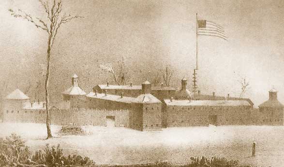
Above is a sketch made by Major Jonathan Hart in 1791. Hart was stationed at the fort.
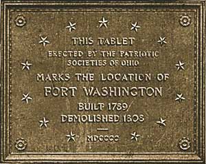
As peace spread across the territory Fort Washington was no longer necessary and was abandoned in 1804. The structure of the fort was assimilated into the growing community of Cincinnati and in time the location of this once vital outpost was lost to history. Years later, most historians believed its location to have been near the corners of 3rd and Broadway, so on June 14, 1901 a 9' tall Ohio stone memorial that mimicked one of the old fort's blockhouses, was placed at that location to commemorate Fort Washington.
During the dedication ceremonies in June, the a detachment of the 2nd Regiment took part in the ceremonies. The 2nd Regiment was first organized at Fort Washington in 1791. As the ceremonies drew to a close, 4 buglers of the Regiment played taps as the last tribute to the memory of those that had served at the fort.
The monument was surrounded by a chain railing supported by four old cannon. The face of the monument towards the west carried 2 bronze tablets, the upper one containing the dedicatory inscription. The lower tablet contained an outline map of the main portion of the fort, together with the streets which intersected it or which surrounded the area.


Photos of the original location of the Fort Washington Monument in the middle of Third Street. The monument was erected by the Societies of the Mayflower, Colonial Wars, Colonial Dames, Sons of the Revolution, Sons of the American Revolution, Daughters of the American Revolution, Children of the American Revolution, War of 1812, and the Loyal Legion.
In 1900 there was much effort made to determine the exact location of the old fort. The location of the fort had come into question in the 1829 when lands that had been purchased by officers living in the fort were put into question. Part of the problem was that the fort had multiple blockhouses, and the fort's plans had been forwarded to the War Department where they were destroyed by a fire in 1809. They therefore had to rely on the memories of people about the size and location of the building that had disappeared some 25 years earlier. Part of their determination on the exact location depended up the sketch (shown above) created by Major Jonathan Hart.
So in 1901 it was determined where the fort once stood and great care was taken for the placement of the monument. However, in 1952 during some construction a few blocks away, workers were surprised when they found some of the actual remains of the fort's powder magazine not far from the Taft Museum and Fourth Street.

Archaeologist surveyed the sight and concluded this was the true Fort Washington location. The monument was moved to the new site in 1998 where it can be seen today just south of E. 4th St. on Arch Street. Should you wish to see replicas of the fort and get a better understanding of how it functioned visit the Cincinnati Museum Center located in the Union Terminal complex.
One interesting point is that the original location of the monument is exactly where I-71 now flows. So the question begs to be answered: did they indeed determine the new location because of the excavations, or was the monument moved to make room for progress? Perhaps the answer is both.
Source: Fort Washington at Cincinnati, Ohio by Robert Ralston Jones, 1903
©
Ohio City Productions, Inc.
All Rights Reserved.

