- Ohio History in 2000 Words
- Mound Builders
- Native Ohioans
- The Ohio Company
- Ohio's Wood Forts
- Indian Wars
- War of 1812
- Ohio's Canals
- Ohio's Road
- Scenic Railroads / Museums
- Underground Railroad
- Civil War in Ohio


Jeffers Mound rests on land owned by the Worthington Historical Society. This single conical mound was part of a larger complex of earthworks. The cultural affiliation is unknown, but archaeological evidence from the 1830s and excavations near its base in the 1970s suggest if may be a Hopewell site from the Middle Woodland Period.
The original earthworks consisted of a rectangular bank enclosure about 3' high with the large conical mound, now known as the Jeffers Mound, a smaller mound in the center, and 2 circular enclosures. The earthworks complex was aligned with the cardinal points and encompassed about 8 acres. The Jeffers Mound lay nearly centered on the south wall of the embankment. The map below shows the complex as it was drawn for Ancient Monuments of the Mississippi Valley, published by the Smithsonian in 1848. The 2 parallel lines on the far right represent the Olentangy River.
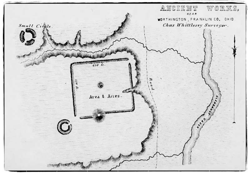
Above: Survey map created by Charles Whittlesey of Cleveland showing the rectangular enclosure and the Jeffers Mound located as part of that wall on the southern side. There was also a smaller mound in the center of the rectangle. Just to the northwest and southwest of the rectange where small circular walls. On the far right of the map is the Olentangy River. Mr. Whittlesey was a a Topographic Engineer of Ohio and contributed twenty maps to the Ancient Monuments publication.
William Vining migrated from Simsbury, Connecticut, to Worthington in 1804, purchasing 203 acres of land that encompassed the area now known as the Plesenton subdivision where the Jeffers Mound is located. He and his descendants farmed the land through the turn of the century. Over time, repeated plowings wore down the embankment walls and smaller mounds; however, they could still be seen as late as 1930.
In 1921, Herman Plesenton Jeffers purchased the land and later, when the Jeffers family platted the land for subdivision in 1954, they did exclude the mound from being developed. In 1974. The Jeffers Trust deeded the mound to the Worthington Historical Society in Herman Jeffer's memory so that it could be preserved in perpetuity. The Jeffers Mound was listed on the National Register of Historic Places that same year.

There were once an estimated 10,000 American Indian mounds and earthworks in the central Ohio Valley. Today, about 1,000 of these ancient landmarks have survived through efforts of private landowners, local, state and federal agencies and conservation groups. Of those sites, only about73 are open to the general public or visible from public places.

Today the Jeffers Mound sits at the crest of the hill where Plesenton Drive diverges from Olentangy River Road just north of Route 161. All visitors are requested to treat the mound and the surrounding neighborhood with the greatest respect. The surface of the mound is easily eroded and visitors are asked to keep off the mound itself.
©
Ohio City Productions, Inc.
All Rights Reserved.

